California’s “Pacific Coast Highway” 50 years ago?
Once you leave Cabo San Lucas heading North on Route 19 — as you leave all the traffic behind — you travel for approximately 15 minutes and you’ll come to a small community called Magriño. As a matter of fact, at Kilometer 100 there’s a big bridge with the same name, so you can exit at either side of the bridge and go west.
Magrino Beach “Up Close and Personal” Once there you’ll see a wide beach that goes for miles in both directions, it’s pretty desolate except for a few ATVs out in the distance (and 3 ATV rental shops close by…).
This is an excellent beach for whale watching since they get pretty close to the shore and they even smile at you when you take their picture. Ok — ok, I’m exaggerating a bit about the smiles, but take my word for it — seriously — this is no swimmable beach! As a matter of fact, there are only a few swimmable beaches on the whole Pacific with one of the most well-known being Los Cerritos Surfing Beach, so please be careful if you want to play with Mother Nature.
As we leave Magriño heading north we now enter what I call ”no man’s land”. I call it that name because there is no civilization on either side of the road. Just the peaceful views of the ocean at a distance and the magic of the desert with its bountiful collection of cacti, elephant trees, and spots of Damina plants here and there. After traveling for approximately 25 minutes we re-enter civilization and a small town by the name of Elias Calles, which I foresee to be a place full of luxury resorts within the next 5 years. Right now this humble community of approximately 500 souls has no electricity, but there are well-founded rumors that within a year all that will change.
As we continue traveling north, we go over a hill, and as we descend, be ready for a spectacular view of Los Cerritos Bay (approximately 7 miles long). Nearby we can see the gated community of Tequila Ranch with many opulent houses scheduled — or already under construction — right on the beachfront, and out in the distance, we see a glimpse of Los Cerritos at the other end of the bay. This 7 mile stretch of land will also see a major transformation within the next few years. I foresee many private developments, from more gated communities with luxurious homes and large parcels of land for your horses to boutique hotels to cater to the affluent in search of peace and quiet.
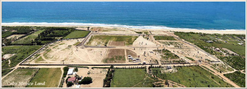
‘Tequila Ranch’ A Gated Community on the Beach
It takes approximately 15 minutes from Elias Calles to Los Cerritos, and this is the area where you see most of the construction of new homes on the beachfront. Los Cerritos has a new beach club and promises of newly-developed condominiums and hotels in the not too distant future.
Cerritos Beach Club – CaboWabo II: Right next door to Los Cerritos we find the village of Pescadero (with the first Pemex gas station after leaving Cabo San Lucas and traveling north to Todos Santos and LaPaz) which was a small and quaint fishermen’s village up until recently. Now! it’s growing by leaps and bounds! It has the infrastructure already in place, many organic and well-manicured farms, the coolest weather in all of Baja Sur during the summer, and even a baseball stadium and boasting much new construction of American-style homes. I have been living and working here for the past 18 months and even I am very surprised at its growth – I expect to see new traffic lights any day now…
Approximately a 7-minute drive north from beautiful Pescadero we arrive in Todos Santos. This place is magic… no wonder the Federal government recently (re)named it Pueblo Magico (Magic Town). It will be disrespectful to describe this town, its people, the history, and its future in a few short lines. So if you bear with me, the next article I write will be devoted to Todos Santos, the North End, Las Playitas, Meliton Albañez, and the new road that will connect Cabo with La Paz in half the time.